
 to open the **Selection** panel. The icon changes color
  .
.
 | Point selection Selects one feature at a time by clicking on it.
As you select features, their information is displayed in the Selection panel. |
 | Line selection Selects features by drawing a line. All features crossed by the line are selected. Note: This option does not work with point layers.
If you draw a new line, the features selected with the first line are deselected. |
 | Circle selection Selects features by drawing a circle. All features entirely or partially included in the circle are selected.
If you draw a new circle, the features selected with the first circle are deselected. |
 | Rectangular selection Selects features by drawing a rectangle. All features entirely or partially included in the rectangle are selected.
If you draw a new rectangle, the features selected with the first rectangle are deselected. |
 | Polygon selection Selects features by drawing a polygon. All features entirely or partially included in the polygon are selected.
If you draw a new polygon, the features selected with the first polygon are deselected. |

| # | Description |
|---|---|
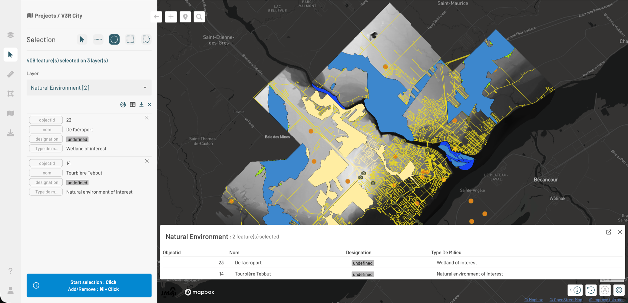
| 1 | Selected features are highlighted in yellow on the map. If you click on a feature while the point selection tool is active, that feature remains selected and the other features are deselected. |
| 2 | This legend indicates the number of selected features and the number of layers involved. |
| 3 | Layer Select the layer whose selected feature cards you want to display. The name of each layer is accompanied by the number of selected features. |
| 4 | Available tools Tools are available for working with the selected features of the layer you indicated in the Layer field. |
| 5 | Feature cards For each selected feature, a card displays the attribute values. |
| 6 | Selection help Help for selecting features on the map. If you use this method, the features selected with the search are deselected. |
 **Zoom to selection**: Centers the map on all selected features in the layer. If the scale changes, the layer may no longer be visible.
*
**Zoom to selection**: Centers the map on all selected features in the layer. If the scale changes, the layer may no longer be visible.
*  **Open attribute table**: Opens a table displaying the attribute data of the selected features. The [Attribute Table](#attribute-table) section presents the table details.
*
**Open attribute table**: Opens a table displaying the attribute data of the selected features. The [Attribute Table](#attribute-table) section presents the table details.
*  **Export to Excel**: Downloads an Excel file containing the attributes of the selected features.
*
**Export to Excel**: Downloads an Excel file containing the attributes of the selected features.
*  **Deselect layer features**: The selected features from other layers remain selected.
### Feature Cards
For each selected feature, a card displays its attribute values.
In each card you can:
* Navigate between selected features.
* Click a card to center the map on the feature
*
**Deselect layer features**: The selected features from other layers remain selected.
### Feature Cards
For each selected feature, a card displays its attribute values.
In each card you can:
* Navigate between selected features.
* Click a card to center the map on the feature
*  Return to the previous view.
* Maximize or minimize the card.
*
Return to the previous view.
* Maximize or minimize the card.
*  Edit the feature (if you have permissions). The [Editing Data](/en/jmap-ng/jmap-ng-user-guide/fonctions/editing-data.md) section provides more details.
* Deselect the feature. The other features remain selected.
### Attribute Table
The attribute table displays the attribute values of the selected features in tabular format. Features are presented in rows and attributes in columns.
Edit the feature (if you have permissions). The [Editing Data](/en/jmap-ng/jmap-ng-user-guide/fonctions/editing-data.md) section provides more details.
* Deselect the feature. The other features remain selected.
### Attribute Table
The attribute table displays the attribute values of the selected features in tabular format. Features are presented in rows and attributes in columns.
 to close the table. The features remain selected.
* Click
to close the table. The features remain selected.
* Click  to open the table in a new tab. The table disappears from the tab displaying the map.
* Close the tab to return to the table displayed with the map.
#### Sorting features
You can sort features based on the values of a given attribute:
1. Hover over the column header corresponding to the attribute you want to use for sorting. An arrow appears next to the attribute name.
2. Click
to open the table in a new tab. The table disappears from the tab displaying the map.
* Close the tab to return to the table displayed with the map.
#### Sorting features
You can sort features based on the values of a given attribute:
1. Hover over the column header corresponding to the attribute you want to use for sorting. An arrow appears next to the attribute name.
2. Click  to sort features in ascending order based on their value for the attribute.
3. Click again to reverse the order. The arrow
to sort features in ascending order based on their value for the attribute.
3. Click again to reverse the order. The arrow  changes and features are sorted in descending order.
#### Navigating between features
You can also use the attribute table to navigate between selected features:
1. Click a feature's row in the table. The map centers on the feature.
2. Click to return to the previous view.
changes and features are sorted in descending order.
#### Navigating between features
You can also use the attribute table to navigate between selected features:
1. Click a feature's row in the table. The map centers on the feature.
2. Click to return to the previous view.