K2 Geospatial 2023
This user guide details the main steps that in JMap Cloud Portal lead to the distribution of JMap Cloud data via a public or restricted access cartographic application.
Each member of an organization has one of three roles in JMap Cloud Portal: administrator, editor, or viewer. The Roles section details the functions specific to each role. Only administrators and editors access JMap Cloud Portal. Viewers access applications that stream data from JMap Cloud. Administrators and editors view all sections of JMap Cloud Portal but only the functions that correspond to their role are activated.
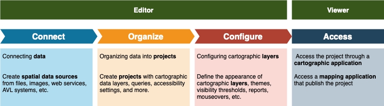
The following figure summarizes the workflow with the roles involved.
This step requires the editor to connect the data to JMap Cloud by creating spatial data sources. These can be GIS files, spatial data servers, satellite images, etc. Files are uploaded and their data is copied into JMap Cloud databases or connections to data web services are created to make the data available to configure projects.
See Connecting Data: Spatial Data Sources for more details on this.
JMap Cloud data is organized into projects. A project contains information about map layer definitions, as well as settings governing access control (security), queries, units, etc. By creating a project, the editor defines the visual appearance of the map and the information it will contain.
See Organizing Data into Projects for more details on this.
In this step the editor creates the cartographic layers of the project. Each layer of the map is associated with a spatial data source. For each layer, the editor defines the style (the way the elements of the layers will be drawn), the labels, the themes, etc. It can also define access control layer by layer.
See Configuring Cartographic Layers for more details on this.
The project is disseminated to end users via mapping applications. Depending on the access controls configured by the editor, the applications may be public or may be accessible through the authentication of the user who holds the viewer role.
The JMap NG User Guide provides details on JMap Cloud mapping applications.